AI Appraisal
Description
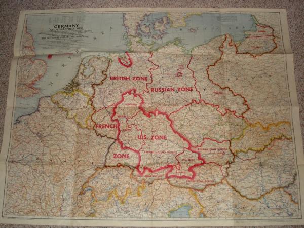
I was given this map as a gift. It was part of my wife's great uncle's WWII belongings. He passed away in 1994, and this was given to my mother-in-law, along with a belt buckle bearing "Sixth Armored Division" and the respective logo on it. From what I know, he fought in the Battle of the Bulge with the United States army. The map was originally printed in National Geographic, but this particular map was printed with occupational zones on it for the military. This particular map has the description, "This edition for use by War and Navy Department Agencies only - Not for sale or distribution." I am not interested in selling this map as I am just now getting started with collecting WWII-related militaria. What I am interested in is the story behind this map and a potential value it may have. Thank you in advance for any help that can be provided.
Category
Militaria
Medium
Paper
Distinguishing marks
n/a
Condition
Good
Size and dimensions of this item
3 ft x 4 ft
Date Period
July 1944 (based on 1938 and 1939 boundaries)
Weight
n/a
History
see below...
eBay Auction Link
Price Paid (If known)
$0
⚠️ You have 1 free appraisal left today
Upgrade for 15-30/day →
Want more from your appraisals?
View Plans →
Upgrade for PDF reports, more daily appraisals, and ad-free experience.


Re: 1944 National Geographic Map - Germany and Its Approaches
Feel sure it came out of the magazine sometime during that year. They often had maps /charts stapled inside. Do you see any staple holes? Could have been just stuffed inside as well. I just got my Dad a 1929 NG magazine. They only had a few color pages back then in each edition. If it from the magazine there are probably many around.
Re: 1944 National Geographic Map - Germany and Its Approaches
Thanks for the response on this item. There are no staple holes in this map. However, there are push-pin holes on each side surrounded by light dirt, meaning it was probably hanging on a wall for a period of time. This particular map did not come out of a magazine as it was a different edition and it is marked for "War and Navy Department Agencies only." Also, I have seen the one included in the National Geographic and it does NOT include the occupational zones.